Sep 21, 2020
Arctic Sea Ice Shrank to Its Second-Lowest Level on Record
, Bloomberg News

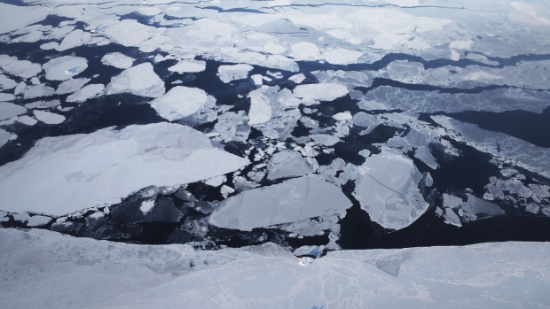
(Bloomberg) -- Arctic sea ice covered 3.7 million square kilometers (1.4 million square miles) in September, the smallest area this year and the second-smallest since satellite monitoring began four decades ago.
The figure marks the second time that Arctic sea ice dropped below 4 million square kilometers, according to data released Monday by the U.S.’s National Snow and Ice Data Center. The all-time low was registered on September 17, 2012, when the ice shrank to 3.4 million square kilometers.
“The year 2020 will stand as an exclamation point on the downward trend in Arctic sea ice extent,” said Mark Serreze, director of the NSIDC, in an emailed statement. “We are headed towards a seasonally ice-free Arctic Ocean, and this year is another nail in the coffin.”
September marks the end of the summer in the Northern Hemisphere, and thus is usually the time Arctic ice is at its annual low. The figure has become a key metric for climate change, and the fact that this year’s low was more than 40% below the average from 1981 to 2010 shows the fast warming of the Arctic. This year’s drop is also far from a one-off—the 14 years with the lowest sea-ice area have all occurred in the last 14 years.
“The rapid disappearance of sea ice is a sobering indicator of how closely our planet is circling the drain,” said Laura Meller, a Greenpeace oceans campaigner on board of the organization's Arctic Sunrise ship. “As the Arctic melts, the ocean will absorb more heat, and all of us will be more exposed to the devastating effects of climate breakdown.”
The Arctic experienced its worst fire season on record for the second year in a row, with giant blazes sending one-third more carbon dioxide into the atmosphere than last year. Satellites captured smoke plumes from the fires spreading over the ice cap, covering an area equivalent to more than a third of Canada. A six-month heatwave saw some parts of Siberia experiencing temperatures 10° Celsius above average in May. Temperatures in the Siberian town of Verkhoyansk hit 38° C (100.4° Fahrenheit) in June, a record for the region.
The low sea ice coverage means sailing routes across Arctic seas that can only be navigated for a few weeks every year opened up earlier than usual, allowing gas, oil and mining companies to ship raw materials from Europe and Russia to China through the Northern Sea Route. In parts of the Arctic, in particular in the northern Kara and Barents seas, the ice edge is the furthest north it has ever been, according to the NSIDC.
The Polarstern, a scientific research icebreaker that’s on a 12-month mission to explore the Arctic, reached the North Pole at 12:45pm on August 19. The ship was able to sail from the northern Fram Strait to the Pole in only six days because much of the sea ice had melted away.
“I’ve never seen that so far north,” Polarstern captain Thomas Wunderlich said in a statement. “Normally it’s wise to avoid the region north of Greenland because it’s home to the thicker and older ice, and virtually impassable—but now we’re finding extended stretches of open water, reaching nearly to the Pole.”
In another sign that Arctic summers are becoming longer and warmer, the Russian city of Norilsk switched on central heating in residential properties and administrative buildings on Monday, compared to September 9 last year. This is the latest date ever, with low temperatures traditionally forcing the operator to turn on city-wide heating during the first days of the month.
The NSIDC cautioned that this is only a preliminary record for sea ice’s seasonal low, and that a more complete analysis will come in October. In two prior years, 2005 and 2010, the ice coverage dipped even lower than the late-September measurement due to changing winds and late-season melts.
©2020 Bloomberg L.P.


