Nov 16, 2020
Iota Threatens to Batter Central America as Category 5 Storm
, Bloomberg News

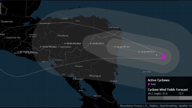
(Bloomberg) -- Hurricane Iota could slam into Central America later Monday as a Category 5 storm, ripping apart homes, touching off deadly mudslides and leaving residents stranded for weeks.The storm will hit near the Honduras-Nicaragua border, the National Hurricane Center said, pummeling a region devastated about two weeks ago by Hurricane Eta, which killed more than 100 people. Iota’s winds reached 155 miles (250 kilometers) per hour early Monday, but the storm continues to strengthen. If it rises to 157 miles per hour, it will be a Category 5 storm, the strongest on the five-step Saffir Simpson scale. Landfall will likely come after 8 p.m. New York time.
“Iota is expected to continue to rapidly intensify and could possibly be a catastrophic Category 5 hurricane when it approaches the coast of Central America tonight,” Stacy Stewart, a forecaster at the center, wrote in his outlook. “Flooding and mudslides in Honduras and Nicaragua could be exacerbated by Hurricane Eta’s recent effects there, resulting in significant to potentially catastrophic impacts.”Iota is the 30th named storm in the Atlantic this year, a record, and it may end up as the season’s strongest. This is the first time the Atlantic has produced two major hurricanes -- Category 3 or stronger -- in November, according to a tweet by Phil Klotzbach, lead author of the Colorado State University seasonal forecast.“There’s not much to say about the forecast, it’s straightforward, and Really Really Bad,” Chuck Watson, a disaster modeler with Enki Research, wrote in his blog.
It won’t matter at this point if Iota gets to Category 5 or even weakens a little before it comes ashore, because disastrous effects are almost inevitable, said Dan Kottlowski, a meteorologist at commercial forecaster AccuWeather Inc.
“This is a humanitarian disaster in the making,” Kottlowski said. “Once a storm gets to 155 mph, it doesn’t matter what you call it, it is a massive death producer.”
The storm will devastate the coastal areas with high winds and deadly storm surge before wringing out flooding rains across the mountains of Central America for the next four days.So many systems have formed in the Atlantic this year that the National Hurricane Center used up its official name list in mid-September and resorted to using Greek letters to designate tropical cyclones. There is a 30% another storm could develop off the coast of Central America in five days.
(Updates with meteorologist’s comments starting in sixth paragraph.)
©2020 Bloomberg L.P.