Sep 1, 2019
Dorian 'off the charts' as it batters Bahamas with 180 mph winds
, Bloomberg News
Commodities update: Gulf refiners keep close eye on Dorian
VIDEO SIGN OUT
Dorian came ashore in the Bahamas tied as the most powerful storm to hit land anywhere in the Atlantic.
The hurricane brought 185 mile-per-hour winds, 10 to 15 inches of rain, and a storm surge that could top 23 feet and leave the islands devastated for years. The fate of Florida remains uncertain as the storm churns in the ocean just 175 miles away.
The eye of Category 5 Dorian struck Elbow Cay about 12:40 p.m. with wind gusts of more than 220 mph (354 kilometers per hour) in addition to its sustained winds, and then moved onto Great Abaco Island, the U.S. National Hurricane Center reported. The storm is about 95 miles (153 kilometers) from Freeport, Grand Bahama Island. It is maintaining its peak winds of 185 mph.
Dorian tied the 1935 Labor Day hurricane, which crushed the Florida Keys, as the strongest storm ever to hit land anywhere in the Atlantic, said Maureen O’Leary, spokeswoman for the National Weather Service.
“I wouldn’t want to be on the Abaco Islands, they are going to have 12 to 15 hours of hurricane force winds with only the eye as the respite,” said Jeff Masters, co-founder of Weather Underground, an IBM business. “Everything in that eye is going to get totaled, it is going to take them years, if not a decade, to recover.”
Roughly 100,000 of the 370,000 Bahamas population live in areas that are going to be hit by the storm, according to Bahamas Finance Minister and Deputy Prime Minister Kevin Peter Turnquest, adding in a response to queries that Abaco suffered “severe destruction of homes and infrastructure.”
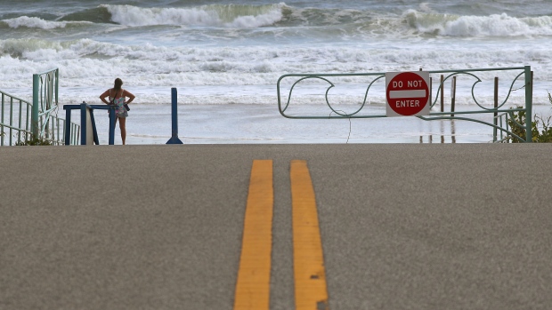
While the devastation mounts in the Bahamas, the threat to Florida and the U.S. East Coast remains uncertain. Hurricane warnings have been posted along the Florida coast from Jupiter Inlet to the Volusia/Brevard county line and storm surge warnings are in place from Lantana to the Volusia/Brevard county line. While many people focus on winds, most hurricane deaths are caused by storm surge and drowning from flooding.
Fluctuations in weather patterns across the U.S. and Atlantic mean Dorian could hit Florida or further up the coast in Georgia or the Carolinas later this week -- or not make landfall at all.
“Life-threatening storm surge and dangerous hurricane-force winds are expected along portions of the Florida east coast through mid-week,” Lixion Avila, a senior hurricane specialist at the center wrote in an analysis. “Only a slight deviation to the left of the official forecast would bring the core of Dorian near or over the Florida east coast.”
Even if Dorian remains 50 miles from shore, though, there could be “a long stretch of wind and storm damage” from South Florida all the way to Cape Hatteras, said Todd Crawford, senior meteorological scientist at IBM’s The Weather Co.
“Minor differences on the order of 50 miles in the eventual track and size of Dorian will mean the difference between millions and billions of dollars in damage and between thousands and millions of power outages,” Crawford said in an email.
Only four Category 5 hurricanes have hit the U.S. mainland, although the previous one was less than a year ago, Hurricane Michael in October 2018, said Phil Klotzbach, lead author of the Colorado State University’s seasonal storm forecast. With top winds of 180 mph, Dorian is tied with Gilbert as the strongest Atlantic hurricane ever measured in September.
Dorian “is going off the charts in a hurry,” Klotzbach said.
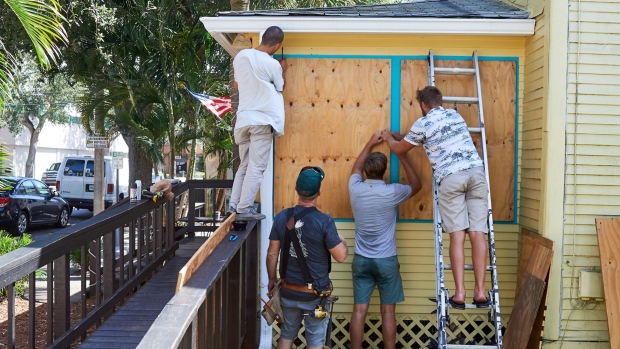
A mandatory evacuation has been ordered for parts of Florida’s Palm Beach County, including the Mar-a-Lago club owned by Donald Trump, which the president often uses as a “Winter White House.” There are also mandatory evacuation orders in place for parts of Martin, St. Lucie and Brevard Counties, all along Florida’s east coast. St. Johns County in the northeast part of the state is expected to issue one tomorrow, according to the Florida governor’s office.
Six other counties are having voluntary evacuations.
Florida’s fate will hang on the strength of a high pressure system in the western Atlantic and how far Dorian can move west. If that system weakens, then Dorian should veer away from the coastline, which has some of the priciest properties in the U.S. If it stays strong, the catastrophic tempest will come perilously close to shore, said Ryan Truchelut, president of Weather Tiger in Tallahassee, Florida.
“The name of the game is forward speed,” Truchelut said. “At this point, monitoring the motion of Dorian tick by tick using radar, satellite, and aircraft observations will reveal potential changes more meaningfully than model guidance; even a 1 mph faster average speed risks bringing the eyewall of Dorian to the east Florida coastline.”
If Dorian doesn’t slow down and stop by Monday, the odds for a strike in Florida rise, said Jim Rouiller, chief meteorologist at the Energy Weather Group outside Philadelphia.
“Florida is not out of the woods until we see it stop and move north,” Rouiller said. “The longer it takes to make the turn, the more Florida is under the gun.”
Hurricanes pack their deadliest winds around the center of the eye. That’s why landfall is so closely monitored because it means the eye has crossed over. Several islands in the Bahamas are in the center of that destructive force.
Elbow Cay, where Dorian came ashore, was described as having a “New England-meets-the-tropics ambiance” by Coastal Living magazine. A Category 5 hurricane will flatten many homes, snap trees and power lines, and leave the area “uninhabitable for weeks or months,” the hurricane center said.
Dorian, one of five storms to form in the Atlantic so far this year, menaced the U.S. Virgin Islands last week. The storm is now forecast to drift up the East Coast later this week possibly even coming ashore in eastern North Carolina.
Storm surges and flooding remained a serious risk for Florida, in part because the storm coincides with a periodic event known as king tides, especially high tides which frequently cause flooding in South Florida even on sunny days. Its current projected turn would also bring it close to the St. Lucie nuclear power station, home to two nuclear reactors owned by Nextera Energy Inc.’s subsidiary Florida Power & Light.
Florida Governor Ron DeSantis said at a Sunday afternoon press briefing that he had just participated in a video conference with Trump, who assured him and other governors that the federal government was prepared to deploy all necessary resources.
Speaking from Tallahassee, DeSantis said he expected county evacuation orders to expand. He suspended tolls on major evacuation routes for affected counties, including along the Florida Turnpike. The shoulders of key roads may also be opened to ease the flow of traffic if necessary, he said. He urged Floridians to obey the evacuation orders.
“This storm, at this magnitude, could really cause massive destruction,” he said. “Do not put your life in jeopardy by staying behind when you have a chance to get out.“
DeSantis acknowledged that the storm was expected to turn north, but he said there was little certainty about exactly when and where the turn would take place, and that continued vigilance was needed up and down Florida’s east coast.
In 2016, Hurricane Matthew veered away from Florida without a landfall but still left massive destruction in Florida, South Carolina and North Carolina from torrential rains. Even a glancing blow could cost upwards to US$7 billion in damage, Chuck Watson, a modeler with Enki Research, said on his blog.
“We are in a situation here where this thing is perilously close to the state,“ DeSantis said. “I think we should all hope and pray for the best, but we have to prepare that this could have major impacts on the state of Florida, and so that’s what we’re doing.”
DeSantis’s office said 4,434 Florida National Guard soldiers and airmen are supporting the state’s efforts in various capacities, including 2,272 guardsmen authorized for state active duty. Dozens of school districts and colleges have announced they’ll close at least through the end of the day Tuesday.
The hurricane center is tracking three other potential storms in the Atlantic. One, near Cabo Verde off Africa, has a 70 per cent chance of becoming a tropical system in the next five days. Another, near the Yucatan Peninsula in Mexico, has a 30 per cent chance. A third disturbance has popped up several hundred miles south-southeast of Bermuda.
“We are dealing with a historic storm,” Rouiller said. “It is probably the strongest storm we have seen so far on the planet this year and the thing is, it is still intensifying.”
--With assistance from Sharon Cho, Mark Chediak, David Baker, Will Wade, Todd Shields, Josh Wingrove, Alyza Sebenius, Michael Riley and Matthew Bristow.

")